Environment.
Data.
Policy.

We run environmental data of Europe. Make it available and understandable. Develop it into policy decisions.

Scroll

15+

years experience

44

data-providing countries

20+

international databases co-managed

42

environmental reports

What we do

From lab readings to international policy briefs — we handle the full lifecycle of environmental data.

Data processing

Collection, validation, and harmonisation of environmental datasets on national level and in EU reporting frameworks. Thematic expertise in freshwater and marine, as well as interoperability between environmental domains.

Information systems

Design and operation of environmental information systems — from national monitoring databases to EU-scale reporting portals, built for interoperability and open access.

All spatial: GIS

Advanced GIS to support environmental reporting and assessments. Compilation of INSPIRE-compliant reference datasets, development of thematic maps, dashboards and dynamic visualisations, automation of spatial analyses, and integration of diverse spatial data sources.

Policy assessment

Evidence-based evaluations for EU environmental policy — impact assessments, compliance analysis, and strategic advisory to national authorities and European institutions.

Featured work

A track record of our key experts delivering data-driven environmental solutions across Europe.

View Details →

Bathing Water Directive: annual quality classification EU-wide

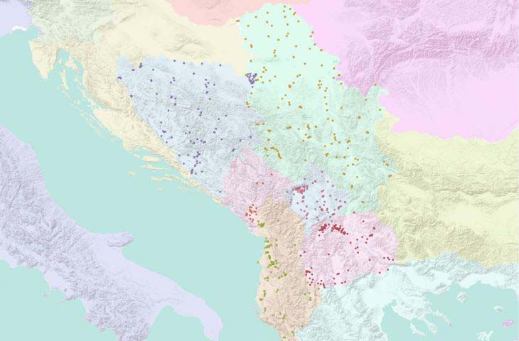
Our experts have developed and ran the workflow of annual data management, processing, and quality classification of 22 000 bathing waters officially identified in the EU and cooperating countries.

View Details →

Marine Strategy Framework Directive data and assessment

Our experts have implemented robust, data-driven methodologies for marine assessments: transforming reported datasets into coherent, large-scale environmental analyses. This includes developing marine indicators (e.g., seabed integrity) to support evaluation of marine environmental status.

View Details →

Water Information System for Europe (WISE)

Our experts have been co-creating the EU freshwater and marine information systems, including data flows and spatial data integration. Includes automated, interactive, and near‑real‑time data viewers that present up‑to‑date assessments, tailored to several audiences from policymakers to general public.

View Details →

Europe's Environment 2025: sustainability dashboards

Our experts have been supporting sustainability transition assessments in the Europe’s Environment 2025 report through automated and standardised dynamic visualisations of key environmental, climate, and socio-economic indicators.

View Details →

Western Balkans and EU Eastern Partnership: capacity building

Our experts have been sharing best practices in environmental (Eionet/WISE) data processing and reporting with 12 countries of the Western Balkans and EU Eastern Partnership. Improving data, interoperability, reporting, and assessments for sustainable development.

View Details →

European freshwater quality and quantity indicators

Our experts have cooperated in developing the workflows for uptaking raw data from Eionet reporting data flows (e.g., WISE SoE) into policy-relevant environmental indicators on the EU-level: Water abstraction by source; Water scarcity conditions; Pesticides in freshwater; Oxygen-consuming substances in freshwater.

View Details →

Environmental impacts of maritime transport in Europe

Our experts have collected, processed, and interpreted data from various institutional sources of marine-related data - to provide knowledge base on pressures on the marine environment, as input to the European Maritime Transport Environmental Report 2.0 (EMTER 2.0).

View Details →

Drinking Water Directive data

Our experts have cooperated in the annual data collection, quality control, and spatial analysis of European drinking water management for more than 55 thousand water supply zones. The data are in support of the drinking water quality assessment to monitor the implementation of related policies of the EU.

View Details →

Droughts and floods in Europe: data dashboards

Combining the latest Earth observation data with ecosystem information to deliver dynamic, up-to-date insights into drought exposure across Europe.

View Details →

River connectivity assessment

Our experts took part in developing the harmonised methodologies to assess river connectivity. Their assessment includes indicators, data frameworks, and analytical tools to support monitoring of ecological benefits and progress when restoring EU rivers into free-flowing regimes.

European river landscape

15+

years
environmental
experience

About Okolys

Okolys is an environmental consultancy specialising in water management data and policy across the European Union. We bridge the gap between raw environmental measurements and the policy decisions that protect Europe's water resources.

Our multidisciplinary team combines expertise in geography, environmental informatics, GIS, and EU policy frameworks. Our experts are involved in the activities and task groups of the EU institutions, national water authorities, and environmental agencies to ensure data-driven decision making at every level.

Based in Slovenia, we operate with data of all 27 EU Member States plus 11 Eionet-involved countries, supporting the implementation of EU environmental policies on national and local levels.

Environmental assessment expertise

Indicators
Indicators Conceptualisation and implementation of environmental indicators: complex environmental data translated into a simplified information that helps policymakers, experts, and the public understand what is happening. We apply data aggregation, visualisation, and textual key messages.
Geospatial analysis
Geospatial analysis Examination of geographically referenced data to detect patterns, relationships, trends, and spatial interactions across locations. This supports evidence-based environmental assessment, planning, and decision-making. We apply industry-standard and open source solutions.
Monitoring reporting
Monitoring reporting Systematic collection, validation, aggregation, and (digital) submission of monitoring data to authorities. This ensures compliance with regulatory frameworks, transparency of environmental conditions, and consistent, comparable assessments aligned with EU reporting obligations. We apply technical and environmental domain expertise for optimal data models and data transfers.
Trend analysis
Trend analysis Statistical examination of time-series data to identify consistent patterns, changes, or rates of increase or decline over time. This supports interpretation of long-term environmental developments and informing evidence-based policy and management decisions.
DPSIR
DPSIR Conceptual framework that structures environmental assessment by linking Drivers, Pressures, State, Impacts, and Responses. It clarifies cause–effect relationships between human activities and environmental change to support policy analysis and decision-making. We apply the framework on national and international level.
Scenarios
Scenarios Structured, plausible descriptions of alternative future developments based on different assumptions about drivers, policies, and uncertainties. Used to explore potential environmental outcomes, assess risks, and support strategic planning and decision-making. We apply data-processing approaches to both, qualitative and quantitative methods of scenario-building.
Visualisation & dissemination
Visualisation & dissemination Presentation of environmental data and analysis through maps, charts, dashboards, and interactive tools. This enables clear understanding, stakeholder engagement, informed decision-making, and effective communication of complex results to diverse audiences. We apply desktop, server, and web frameworks of dissemination.
Impact assessment
Impact assessment Systematic evaluation of potential or actual environmental, social, and economic effects of policies or projects. This supports informed decision-making, mitigation planning, and sustainable management. We apply data-processing approaches to both, qualitative and quantitative methods of impact assessment.

Policy expertise

WFD
Water Framework Directive (WFD) EU Directive 2000/60/EC establishing a framework for the protection of inland surface waters, transitional waters, coastal waters and groundwater. It requires member states to achieve "good status" for all water bodies by set deadlines through River Basin Management Plans.
BWD
Bathing Water Directive (BWD) EU Directive 2006/7/EC is aimed at protecting public health by monitoring and assessing the quality of designated bathing waters. It requires regular sampling, classification, and transparent information to the public towards better bathing quality management.
DWD
Drinking Water Directive (DWD) EU Directive 2020/2184 is a framework ensuring the safety and quality of water intended for human consumption across the EU. It sets health-based standards, monitoring requirements, and risk-based management obligations.
FD
Floods Directive (FD) EU Directive 2007/60/EC is focused on reducing and managing flood risks to human health, the environment, cultural heritage, and economic activity. It requires flood risk assessments, hazard and risk mapping, and flood risk management plans.
MSFD
Marine Strategy Framework Directive (MSFD) EU Directive 2008/56/EC works towards achieving Good Environmental Status (GES) of EU marine waters through ecosystem-based management. It requires marine assessments, monitoring programmes, and coordinated measures at regional sea level across 11 illustrative qualitative descriptors.
INSPIRE
INSPIRE Directive EU Directive 2007/2/EC established a European spatial data infrastructure to support environmental policies and activities with a spatial dimension. It defines harmonised data models, metadata standards, and interoperable services, thus enabling sharing, viewing, and accessing standardized spatial data.
Eionet Strategy
Eionet Strategy Strategic framework guiding cooperation between the European Environment Agency (EEA) and its member and cooperating countries. It strengthens coordinated data flows, capacity building, and digital transformation for environmental reporting.

Technical expertise

Database architecture & management
Database architecture & management Design, structuring, optimisation, security, and maintenance of reliable spatial and non-spatial database systems. Includes data modelling, indexing, performance tuning, backup strategies, access control, interoperability, and ensuring data integrity, scalability, and long-term sustainability across distributed environments.
Data flows
Data flows Design and orchestration of automated pipelines that collect, validate, transform, harmonise, and integrate data from multiple sources into structured systems. Ensures quality control, standardisation, traceability, timely updates, and reliable delivery for analysis, reporting, and decision-making processes. We focus on flows of environmental data across institutional settings.
Data validation
Data validation Design and application of structured quality control procedures to verify accuracy, completeness, consistency, and compliance with standards. Includes automated checks, rule-based testing, anomaly detection, metadata review, and documented correction workflows to ensure reliable, trustworthy datasets.
Spatial processing
Spatial processing Analysis, transformation, and modelling of geospatial data to derive spatial patterns, relationships, and indicators. Includes overlay operations, buffering, interpolation, network analysis, raster processing, automation with GIS and scripting tools, and optimisation for large, multi-source datasets.
Interactive maps
Interactive maps Design and development of web-based interactive mapping applications enabling dynamic exploration of spatial data, indicators, and assessment results. Includes layered visualisation, filtering, querying, dashboards, user-driven analysis, performance optimisation, and integration with live databases and reporting systems.
Interoperability/ETL
Interoperability/ETL Design and implementation of data exchange and Extract/Transform/Load (ETL) processes on heterogeneous datasets across systems. Ensures standards compliance, semantic harmonisation, metadata alignment, automation, and reliable integration of environmental data between national, European, and thematic infrastructures.
Data visualisation
Data visualisation Design and production of clear, policy-oriented visualisations that translate complex datasets into understandable visual insights. Includes charts, dashboards, maps, and interactive tools that highlight trends, comparisons, and uncertainties. This supports transparent communication and evidence-based decision-making processes.

The team

A core group of specialists and Okolys founders cooperates with thematic experts from various fields of environmental science related to Okolys network. Together they bring hands-on experience in environmental science, data handling, and national and international policies.

Andrej Draksler

Andrej Draksler

Founder · Spatial/GIS analyst

Expert in spatial aspects of European environmental reporting - particularly under the Marine Strategy Framework Directive (MSFD), Water Framework Directive (WFD) and WISE SoE spatial (WISE5) data flow. He supports the development and implementation of spatial protocols and quality control procedures to harmonise reported data. Combining hydrogeographical expertise with advanced GIS, he develops EU-wide methodology for assessing river connectivity to support free-flowing rivers objectives under the EU Nature Restoration Regulation.

Gašper Šubelj

Gašper Šubelj

Founder · Policy assessment expert

Expert in IT approaches towards tracking the environmental policies of Europe. Collaborates with the European Environment Agency on Eionet dataflows and water quality assessments, sharing best practices with national institutions in the Western Balkans and EU Eastern Partnership. Task lead in the activities of European Topic Centre Biodiversity and Ecosystems: Bathing Water Directive data and assessment; Content development for Water Information System for Europe; and Marine Litter Watch.

Luka Snoj

Luka Snoj

Founder · Data architect

Database and GIS specialist collaborating with the European Environment Agency, with a strong focus on MSFD and marine data. He develops methodologies that turn national reporting into quality information products - including interactive maps, dashboards and indicators published on WISE Marine. He also co-manages the BWD dataflow and supports data processing for the Nature Restoration Regulation (NRR), including floodplain assessments and river connectivity. Task lead for the activities of European Topic Centre Biodiversity and Ecosystems: Marine data and data products.

Fun fact:

Contact

We are available for progressive environmental projects, requests to tame floods of data, or swift questions.

Company name

Okolys, environment and data, Ltd   |   Short name: Okolys

Email

Location

Ziherlova ulica 22, Ljubljana, Slovenia

Company Registration Number

7450206000

VAT Number

SI25206443